


Connect With Us
Visit Us
250 West Nyack Road, Suite #200 West Nyack, NY 10994
Get Directions
Call Us Toll Free
877-GO-RUSTY
877-467-8789
Telephone
845-369-6869
Fax
845-228-8177
Departments
Departments
Departments
SUBSCRIBE TO NEWSCONTACT US
Users have already become accustomed to the vector based maps, the turn-by-turn car navigation, and maybe even the public transit directions available to the Android version of Google Maps/Navigation. However, a Maps update available now to all Android phones provides some handy features such as turn-by-turn (or rather, stop-by-stop updating as you go) public transit navigation, improved search suggest, and what I like to call "multi-gesture" interaction.
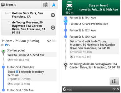
Public Transit Navigation
Much like Navigation tells you when to turn, when to expect the next turn or road, and how long until you reach your destination, Transit Navigation will track you as you are traveling on bus and/or train (or walking) and tell you which stop to get on/off at and approximately when. It is a huge help to also have the public schedules integrated into the system, all pulling from live data -- and of course will pre-download future directions and vector data in case the internet connection is lost. Public Transit Navigation is available in over 400 cities around the world.
Multi-gesture Interaction
Maps has always had the familiar multi-touch gestures such as pinch to zoom in/out, drag to pan, rotate in a circle to rotate map, or slide fingers parallel up/down to change perspective. Now it seems you can combine some of these multi-touch actions to do more than one thing at once, instead of one-after-the-other. It's kind of hard to explain, but to put it simply, you can pan/rotate/zoom the map very quickly without taking your fingers off the screen.
Pre-download any 10 by 10 mile square
Accessible from the "Labs" menu of the app, you can enable the ability to pre-download a 10x10 mile portion of the map, anywhere in the country. Because it is vector data that means you get the 10x10 mile square at all zoom levels. This can be helpful if traveling to a relative or friend's town and you want to save battery or internet usage around town while you're there.

Google Navigation assisted my friends and I
while driving around Southern California in a rental car.
Plus some additional features:
Source: Official Google Blog
250 West Nyack Road, Suite #200 West Nyack, NY 10994
Get Directions
877-GO-RUSTY
877-467-8789
845-369-6869
845-228-8177
1 COMMENT